|
|
| Special instructions A cool hike for a warm morning? |
|
|
Directions From Interstate 210 in La Canada, take Angeles Crest Highway 16km (10 miles) to the top. You will pass the ranger station (Clear Creek Information Center on the right) STOP in and buy a pass if you dont have one.
Continue past this about 200 meters to the top parking lot, go through the gate and descend down to the lower parking lot.
The start of the hike is a nicely designed small footbridge.
For the GPS addicted (like myself) enter this coordinate into your GPS @34.266154,-118.144231
Map: http://goo.gl/5FjJd |
|
The Good Amazing views! A real work out. Wonderfully diverse terrain. |
|
The Bad - It can be very cold either at the top or bottom, so bring layers of clothing.
- Pay parking: $5 for day pass, or $35 for a year pass, required. Passes can be obtained several ways: the Clear Creek Station, Big 5, Sports Chalet, REI, or on the park's website: http://www.fs.fed.us/r5/angeles/
|
|
Where Bear Canyon - Angeles National Forest |
|
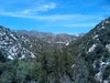
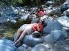
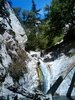
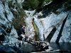
Notes This is great hike into one of the loveliest sections of the San Gabriel mountains. The hike meanders back and across the stream running down the spectacular Arroyo Seco Canyon.
The stream is lined with oaks and alder, with the water cascading over granite into mirror-like pools. The hike travels high above the 50 foot high Switzer falls, then drops back to the stream, where hikers can double back to stand at the base of the falls.
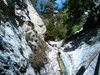
After seeing the falls, travel down stream to the intersection with Bear Canyon, and travel up this spectacularly wild, steep walled canyon for another half mile or so to enjoy its wonders.
You will need to purchase a parking pass in order to park anywhere near the trail.
The Clear Creek Station is located at the intersection of Angeles Crest Hwy and Angeles Forest.
Los Angeles River Ranger District: 818.899.1900.
Clear Creek Station: 626.821.6764 - It is not always open generally during the week. It is almost always open on the weekend.
|
|
| More details |
(Hikers have been notified by email) |
|